Paolucci, R., Mazzieri, I., Smerzini, C. & Stupazzini, M., (2014). Physics-based earthquake ground shaking scenarios in large urban areas, in Perspectives on European Earthquake Engineering and Seismology, Geotechnical, Geological and Earthquake Engineering, vol. 34, chap. 10, pp. 331–359, ed. Ansal, A., Springer.
Introduction
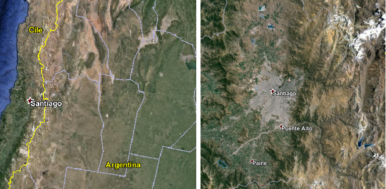
The Santiago metropolitan area (Chile) was selected as a key site for the project purposes owing to: (i) high seismic risk; (ii) availability of 3D geological and geophysical data describing the deep and sub-surface velocity structure (Pilz et al.,2010); (iii) properly characterized seismogenic faults affecting the seismic hazard of the area.
Numerical Model
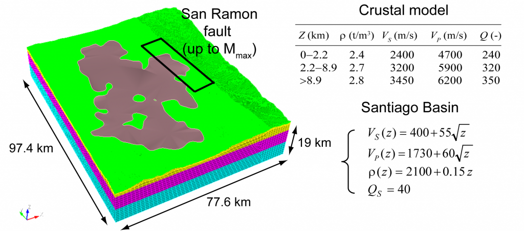
The numerical mesh includes an extended model of the seismogenic structure of interest, namely the San Ramon fault, apt for generating different magnitude levels up the maximum magnitude associated to the fault based on geological considerations. For the San Ramon fault a maximum Mw = 7.1 was assumed (Armijo et al., 2010), implying a maximum size of the rupture area of about 40 km x 20 km.
The hexahedral conforming mesh, designed to propagate up to maximum frequencies of about 2 Hz, consists of 1.108.985 elements, yielding a total number of 31.050.124 nodes for a polynomial degree equal to 3.
Numerical Results
Peak Ground Velocity Map
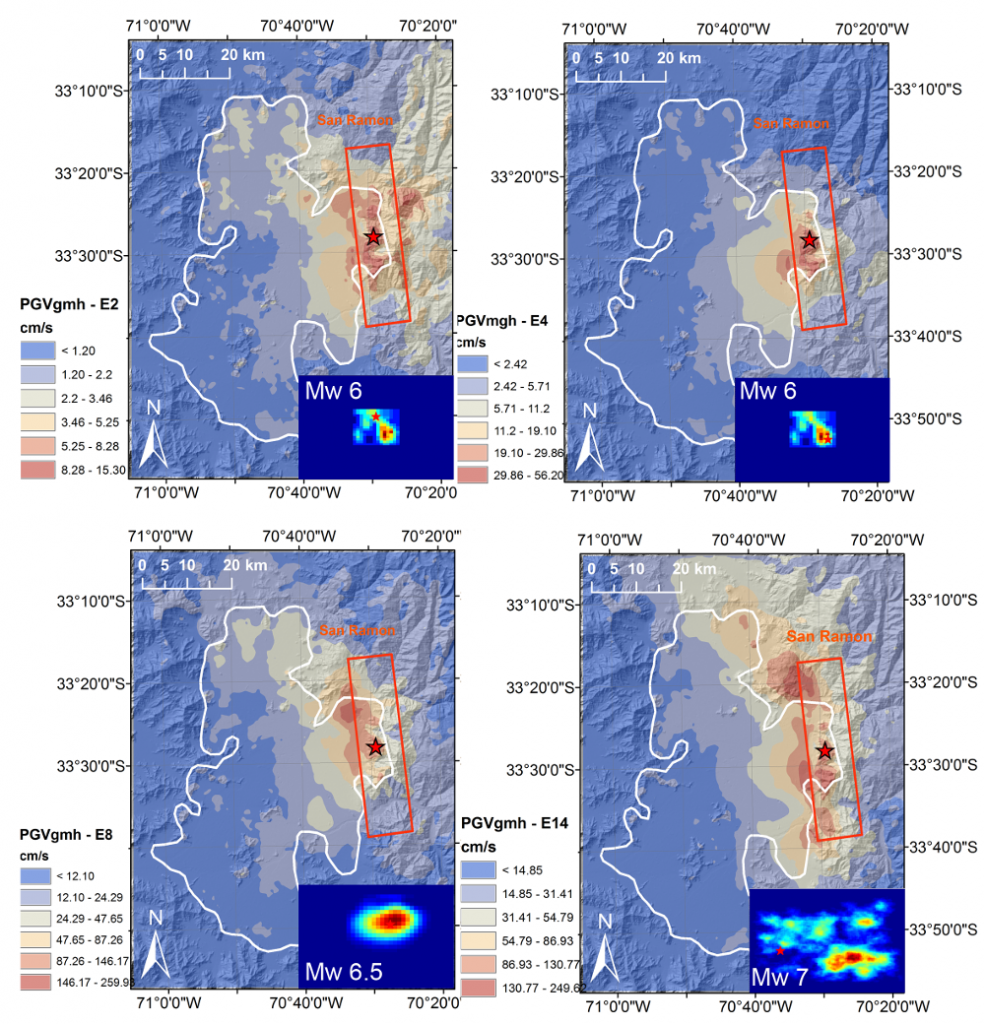
In addition to the development of the computational model, the research activity has focused on the improvement of the pre-processing tools for the generation of arbitrarily defined earthquake scenarios, making them particularly suitable for the objectives of this project. In detail, such tools allow one to prescribe in a semi-automatic way the ”activation” of any potential rupture area and any nucleation point along a given seismogenic structure (with prescribed maximum magnitude), characterized by target magnitude, co-seismic slip distribution and other kinematic source parameters arbitrarily defined by the user. The scenarios were defined according to specific considerations to provide a representative picture of the hazard of the area under study, at least for the selected seismogenic fault.
Examples of ground shaking maps in terms of PGV (geometric mean of horizontal components) for four of the aforementioned scenarios are reported.
Comparison with GMPES
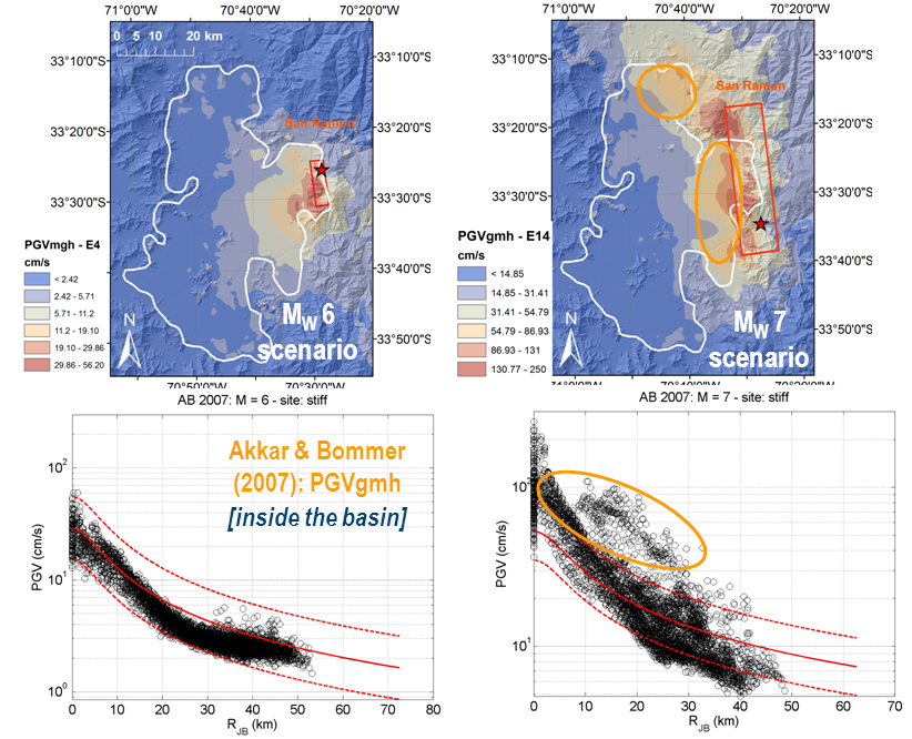
To appreciate the potential interest of these numerical simulations, we show at top two representative scenarios in terms of PGV distribution in Santiago, and, at bottom, the simulated PGV variation with distance compared to the one predicted according to the empirical equation of Akkar and Bommer (2007). While, for the Mw6 scenario, there is an overall agreement of ground motion predicted by both approaches at stiff sites within the basin (EC8 class B), for the Mw 7 scenario the empirical equations are not fit to predict neither the very high near-fault PGV values, related to a fault slip mechanism affected by directivity, nor the high amplification levels at the edges of the basin in the vicinity of the fault (shaded areas).
References
Akkar S, Bommer JJ (2007). Empirical prediction equations for peak ground velocity derived from strong motion records from Europe and the Middle East. Bulletin of the Seismological Society of America, 97: 511–530.
Armijo R, Rauld R, Thiele R, Vargas G, Campos J, Lacassin R, Kausel E (2010). The West Andean Thrust (WAT), the San Ramon Fault and the seismic hazard for Santiago (Chile), Tectonics, 29: TC2007, doi:10.1029/2008TC002427.
Pilz M, Parolai S, Picozzi M, Wang R, Leyton F, Campos J, Zschau, J (2010). Shear wave velocity model of the Santiago de Chile basin from ambient noise measurements: a comparison of proxies for seismic site conditions and amplification. Geophysical Journal International, 182: 355–367.
