![]() Data available in the OneDrive repository.
Data available in the OneDrive repository.
If you want to get the access to the data please write an e-mail to speed.polimi at gmail.com
R.Paolucci, I. Mazzieri, A.G.Özcebe, C. Smerzini, M. Stupazzini, M.Infantino (2017). 3D Physics Based earthquake scenarios in Istanbul for seismic risk assessment. In Proceedings of the 16th World Conference on Earthquake Engineering, 16 WCEE 2017, Paper N° 1478
M. Stupazzini, M. Infantino, A. Allmann, M. Kaeser, R. Paolucci, I. Mazzieri, C. Smerzini (2015). PSHAe (Probabilistic Seismic Hazard Assessment enhanced): the case of Istanbul. In Proceedings of the Tenth Pacific Conference on Earthquake Engineering Building an Earthquake-Resilient Pacific. Paper N° 136.
Why the Istanbul area
The Istanbul-Marmara region of northwestern Turkey with a population of more than 15 millions, faces an high probability (62 +/- 15 %, ref [6]) for the occurrence of an earthquake of magnitude 7 or more. The cause can be found in the seismic gap beneath the Sea of Marmara, some five miles west of Istanbul: since the disastrous 1939 Erzincan earthquake (Magnitude 7.9), major earthquakes have occurred along the North Anatolian Fault (NAF) in a roughly domino-like fashion, breaking sequentially from east to west. The chain of earthquakes along the North Anatolian fault presents a gap at south of Istanbul as shown in Figure 1.
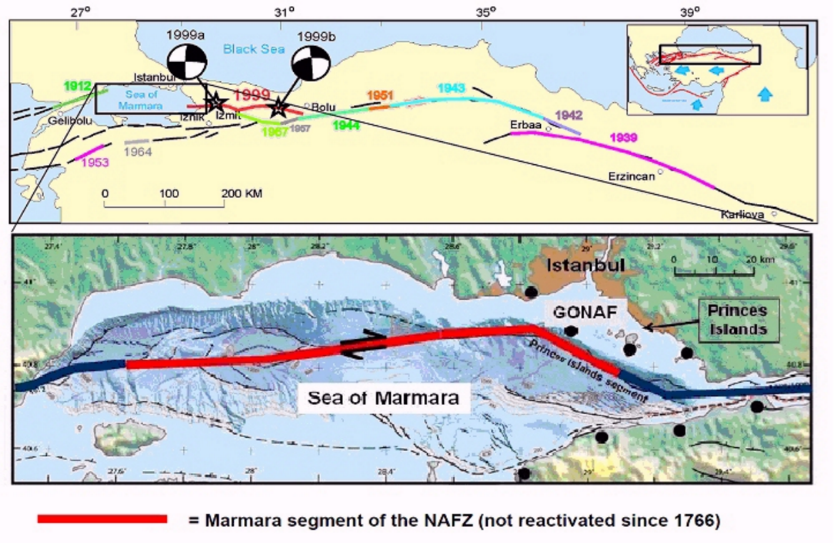
Figure1. Top panel: sites and the length of the fractures of the NFA; bottom panel: seismic gap at the Marmara sea, the red segment of the NAFZ has been not reactivated since 1766. From Bohnoff et al. (2016).
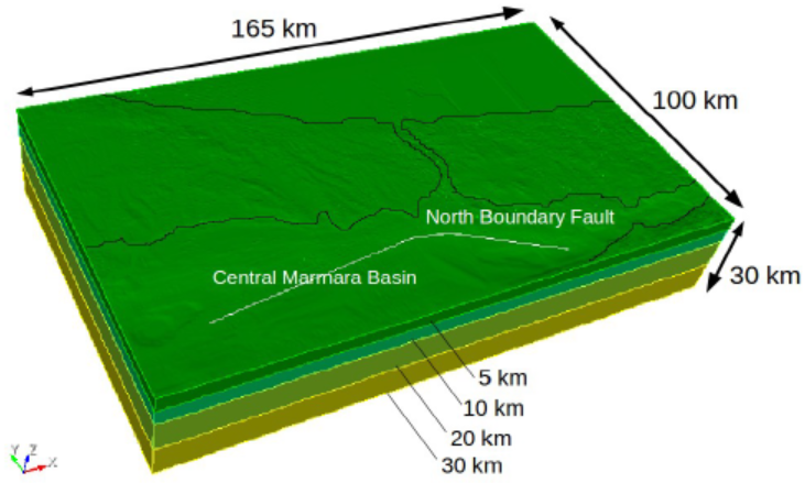
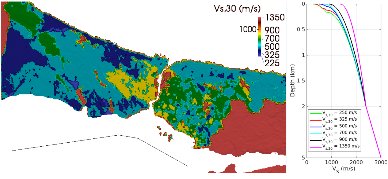
Figure 2. Top: computational domain of the Istanbul region adopted in the present work. Fault system (CMB and NBF) included in the domain as well as topography and bathymetry model. Bottom: vs,30 classes defined according to Özgül, 2011 (left). VS, profiles adopted in the present work for the six soil classes considered in the first layer (0 to 5 km depth) of the computational domain.
Numerical Model
The 3D numerical model was constructed by combining the following features: (i) the topography and bathymetry model; (ii) the kinematic seismic fault model; (iii) the 3D velocity model.
The seismic fault considered consists of the Central Marmara Basin (CMB) and North Boundary Fault (NBF), part of the NAF, located about 20-30 km south-west and south of Istanbul respectively, as shown in Figure 2. The source is a vertical segmented fault, consisting of three main segments with different strike angles. The total length of the fault is around 98 km, capable of producing a MW 7.4 event.
The computational domain, which extends over an area of 165 km x 100 km down to 30 km depth (see Figure 2), has been built combining all the information previously described. The mesh was created in order to propagate frequencies up to about 1.5 Hz. The model consists of 2,257,482 hexahedral elements, resulting in approximately 475 million of degrees of freedom, using a fourth order polynomial approximation degree. The conforming mesh has a size varying from a minimum of 180 m, on the top surface, up to 600 m at 2 km depth and reaching 1800 m in the underlying layers.
Numerical Results
Peak Groung Velocity Maps
A total of 51 scenarios were simulated by varying the magnitude, from 7.0 up to 7.4, the kinematic slip distribution, the hypocenter location and the location of the rupture area.
First, Figure 3 shows the simulated velocity time histories for a MW7.0 scenario at some strategic sites in the Istanbul area, superimposed on the PGV map, for the Horizontal (x, y) components. Synthetics are processed with an acausal Butterwort filter with high and low pass frequency equal to 0.05 Hz and 1.5 Hz, respectively, the latter being related to the frequency limit of the numerical model.
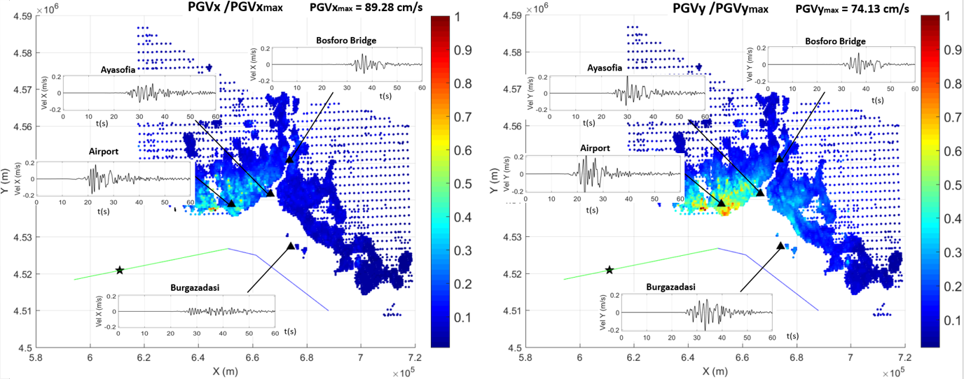
Figure 3. Velocity time histories superimposed on the PGV map for the vertical (bottom panel) and the two horizontal (top panels) components of a scenario of magnitude 7.0 for some strategic sites (Ayasofia (ing. Haghia Sophia), Airport, Bosforo (ing. Bosphorus) Bridge and Burgaz Adası). The scheme of the fault, epicenter (black star) and the active segment (green) of the considered scenario are also shown.
Analysis of the set of PBEs
Finally, the analysis of the set of PBSs as a function of earthquake magnitude (7.0 vs 7.2 vs 7.4) has led to the identification of interesting forward directivity conditions. Contrarily to case of an earthquake of MW=7.0, when an earthquake of MW ≥ 7.2 occurs, the rupture will always involve the three segments of the NFA. In these cases Istanbul will be always interested by forward directivity effects, owing to its unlucky position with respect to the propagation of rupture, leading to a strong amplification of ground motion. On the other side, for events of MW 7.0, it is possible distinguish between forward, neutral and backward directivity depending on the combination of the relative position of the hypocenter and slip distribution. These directivity effects, specific for large magnitude events (MW ≥ 7.2), cannot be taken into account by the standard GMPEs, which are poorly constrained in the near-source region of large earthquakes. It is apparent (cf. Figure 4) that for the simulation set with MW =7.2, the residuals are always positive, i.e., the values of ground motions simulated are higher than that predicted by GMPEs for all sites.
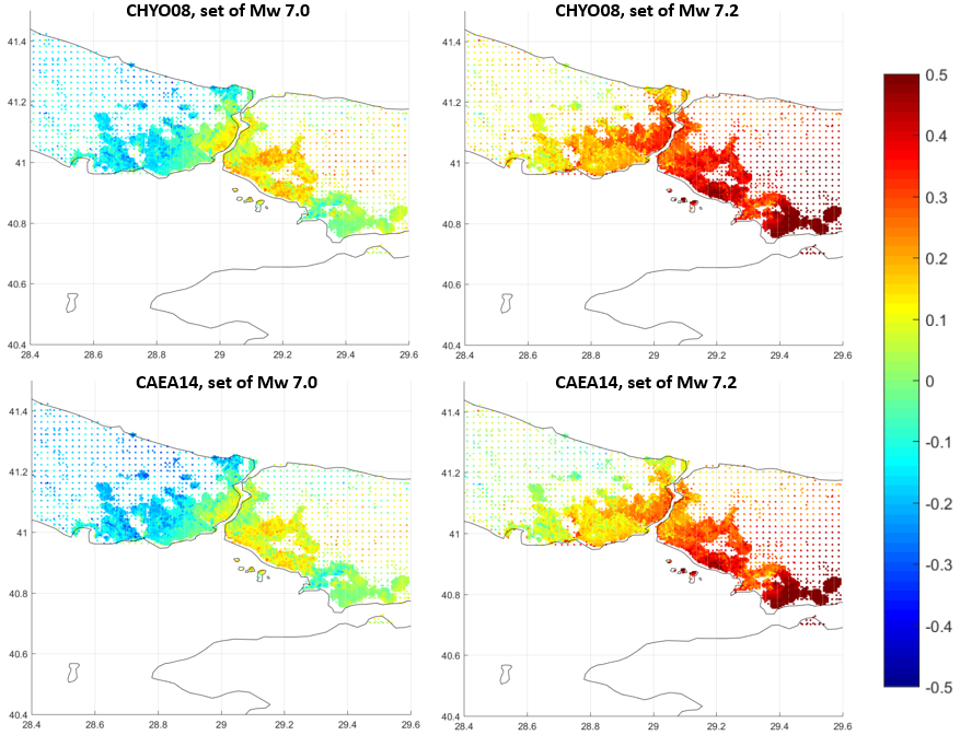
Figure 4. Comparison between the mean residuals, in terms of PGV, of the set of simulated scenarios of MW 7.0 (left) and that of MW 7.2 (right) with respect to two GMPEs (top: CHYO08 = Chiou and Youngs, 2008; bottom: CAEA14 = Cauzzi et al. (2014)).
References
Bohnoff M, Martіnez-Garzon P, Bulut F, Stierle E, Ben-Zion Y (2016): Maximum earthquake magnitudes along different sections of the North Anatolian fault zone, Tectonophysics, 674 (2016),147-165.
Chiou B S-J,Youngs R R (2008): An NGA model for the average horizontal component of peak ground motin and response spectra, Earthquake Spectra, 24(1), 173-215.
Cauzzi C, Faccioli E, Vanini M, Bianchini A (2014): Update predictive equations for broadband (0.01 to 10 s) horizontal response spectra and peak ground motions, based on a global dataset of digital acceleration records, Bulletin of Earthquake Engineering, 13/6, 1578-612.
Özgül N (2011). İstanbul İl Alanının jeolojisi. Yönetici Özeti. İstanbul Büyükşehir Belediyesi, Deprem ve Zemin İnceleme Müdürlüğü (in Turkish).